So yesterday the rain started exactly at 2pm, when the first of the very outer bands of Hurricane Irene reached us. Around 3pm was the worst, when it was so dark the streetlights came on and we had a downpour so thick we couldn’t see the house across the street. You can see the radar picture below that I took 22 minutes before the first rain — we’re at the white crossed-circle on the map. At that point the eye of the hurricane was still something like 400 miles away (Baltimore).
By 4pm, when we were trying to get out barbecue grille into the basement, it was back to just light rain.
The rest of the day and evening alternated light rain and very still, windless, rainless conditions.
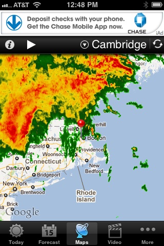
This morning I woke up to find we hadn’t lost power in the night, Internet is still on, and it’s not even raining at all now — and Irene was downgraded to a tropical storm. The eye took a northward track after hitting New York City and they are currently being hammered by heavy rains and wind in upstate New York. The eye is missing us by about 180 miles, and the way the rain bands have formed… we’re being especially spared. Check out the radar photo below to see what I mean! We’re where that red pin is in the map.
I haven’t checked all the news reports yet on how much flooding may have happened at the coast or in the harbor, but right now, it’s actually ALMOST sunny, not raining at all, and although it’s windy, even the gusts don’t seem as strong as we get in a typical winter nor’easter. High tide this morning at 11am was supposedly 9.7 feet, and they’re expecting the 11pm one to be around 11 feet in Boston Harbor. (Several feet above normal.)
My thoughts and prayers to those who are still in the storm track. That’s still a lot of water, folks. (A tweet from friends near the eye say they’ve gotten 5 inches already today and it’s still coming down.)
Photos under the cut!


Now I get to eat all the brownies and cookies I baked yesterday as comfort. 🙂
